| Trail Map | ||
| Distance: 11.5km | Time: 2-4 hours | Difficulty: Strenuous |
| Ascent: 335m |
Click here to go straight to trail notes.
1948: Israel’s War of Independence. From the very beginning it was clear that the residents of Jerusalem were in trouble. The Holy City, isolated from most of the major Jewish settlements further west, was being placed under siege.
With over 100,000 inhabitants, Jerusalem required truckloads full of food and supplies to be delivered from outside of the city, every single day. These supplies had always arrived via the main road into Jerusalem, through Sha’ar HaGai, otherwise known as Bab El Wad (The Gate of the Valley).

Since the surrounding areas were Arab dominated, Jerusalem had a big problem. As hostilities intensified, one of the enemy’s top priorities became cutting off the Jewish Jerusalem’s supply chain. Every day, truck convoys made the long ascent from Hulda (near the coast) to Jerusalem. And every day Arab soldiers and locals would descend from the hills and attack. Soon, it became nearly impossible for trucks to pass Sha’ar HaGai into the city of Jerusalem.
After months of losing precious lives and supplies, the Jews were forced to come up with a new solution – they would build a bypass road, through the rough mountain terrain near the city. The Jews named this new pathway “Burma Road,” after the road linking Burma to Southwest China built during the Second World War. The goal of this secret bypass road would be to provide Jerusalem with supplies, circumventing Arab territory. It took weeks of hard labor, but ultimately, Burma Road was completed.
In the Footsteps of History
A few weeks ago, our interest was piqued about this incredible historical road, not too far from our home near Jerusalem. After reading about it extensively, we decided that we wanted to re-visit Burma Road ourselves. I wanted to traverse the mountainous path traveled by courageous Jewish heroes, as they struggled to feed Jerusalem in 1948.
To get a real sense of the area, we decided to tackle this path in three stages:
- A bike ride along Burma Road, up towards Jerusalem
- A circular hike towards the Sha’ar HaGai lookout and
- A visit to Chan Sha’ar HaGai, a new museum built by the Parks Authority
We learned so much during our explorations. Traveling in the footsteps of the Jews of 1948 gave us a better sense of events as they happened on the ground, during the founding of the State of Israel.

On part one of our journey, we covered most of the long bypass road built from the area of Hulda (near Moshav Bekoa) to Jerusalem. Here’s how we biked it:
The Back Story
Burma road was built under a veil of secrecy. To forge the hidden path, Jews labored through the day and night. They had to pave the way to Jerusalem as quickly as possible, without attracting enemy attention. This meant constant backbreaking labor, often undertaken with subpar tools and machinery. And even once the road was “finished” there were still some parts that were too steep and treacherous to traverse by truck.

Because of this, the first deliveries made along the Burma Road were carried on foot by middle aged conscripts to the army. Each man carried a 45-pound load on their back, walking through the night to reach Jerusalem. Some died along the way.
Eventually, the road was improved enough for jeeps to pass through. Burma Road was finally opened to vehicular traffic on June 10th, just in time for the UN ceasefire. It remained the main passage to Jerusalem for several months afterwards, until a new road was built.
The Bike Ride
On part one of our journey through Burma Road and Sha’ar HaGay, we ascended on Burma Road from Israel’s lowlands towards the city of Jerusalem by bike. Part of the challenge of building and traversing Burma Road in 1948 had been the difficulty of climbing over rough mountain terrain, by jeep and by foot. We wanted to experience what that terrain was like for ourselves.
So, one June morning, we drove our bikes over to the starting point near Moshav Bekoa and set out on the trail. A small sign overgrown with weeds announced that we were on Burma Road. There was a rusty map that laid out the trail.

Once we were on our way, there was plenty to see. We passed by signs and maps outlining the various pathways into Jerusalem of 1948. This helped us get a sense of just how treacherous the approach to Jerusalem had been: enemies surrounded the Jerusalem road on all sides.
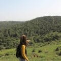
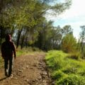
The scenery along Burma Road was mountainous, wild, and beautiful. Some of the terrain was quite difficult to traverse on a bicycle – it mustn’t have been an easy road to build.

Soon, we reached the first stop at Beit Hakeshatot, an old arched building that served as the site of a wrongful execution of an Israeli general in 1948. We explored the inside of the abandoned structure. The dark rooms once served nearby Beit Jiyz, an Arab community we’d read about in history books.
To the Har-El Lookout
After a stop at Beit Hakeshatot, we continued on our way, soon reaching the next main stopping point at the Har-El Lookout, inside a pretty KKL forest. After refilling our water, we headed on over to the display, full of maps and graphics that depicted the area’s terrain and outlined the incredible history of Burma Road.
The Har-El lookout is the official start point for Burma Road – this where most people begin their tour of the historical trail.

After looking through all the displays, we continued through the fields. As we rode along, we passed by display signs with photos of Palmach soldiers on the path in 1948.
Soon after, we reached the Israel Trail. From there, we began biking through a beautiful, shady forest.
Tough Terrain and History on the Trail
From the forest, we continued along an open path, passing by many more interesting sites as we pushed forward. There was the Ha-Shiloach pipeline, a bypass waterline built by Mekorot to supply water to Jerusalem during 1948. Aside from food and supplies, fresh water was essential to the survival of Jerusalem.

If our goal had been to experience the tough terrain of Burma Road, we definitely succeeded. Parts of the path were so unforgivingly mountainous that we (novice cyclists) deemed it safer to walk our bikes down the path. It’s hard to imagine how heavy food convoys made their way through this challenging terrain.
Towards a Spring
Eventually, after some smooth coasting, we reached Ein Mesila. In 1948, road workers, truck drivers, and soldiers used this shallow spring as a main source of water. Nowadays, it’s a pretty picnic spot, with flowing water and picnic tables in the shade of many tall trees. We hopped off our bikes and sat by the spring.
Burma Road continued on, but this is where we were stopping for the day. We had reached the toughest part of the ascent up to Jerusalem. We would have to tackle that section next time.
After a short rest, we hopped back on our bikes and turned back the way we came. We were ready to coast, back downhill to the start point. It had been an amazing morning.
On our journey along Burma Road, we experienced the terrain traversed by heroes of the past. Our ride gave us a glimpse into what it was like to travel this vital path into Jerusalem in 1948.


Trail Notes:
Here’s what you need to know to bike or hike this trail along Burma Road:
- This trail is best suited to the winter and spring. During the summer and fall, it is dry and somewhat exposed.
- This is a one way trail.
- You can bike this trail OR hike this trail.
- For biking newbies like us, this was a challenging trail. Not for kids.
- The trail is not always well marked. Keep a close lookout for trail markers, and use the Google Earth file to find your way on the trail.
- There are no bathrooms, but there is a water point at the HarEl Lookout.
- To find your way: Begin on the red trail from the start point. Follow the red trail until you reach the Israel Trail. Continue following Israel Trail/ Red Trail to the end.
Don’t forget to read my guide to the navigational features in this post before you hit the trail!
Trail map from Amud Anan.
Questions? Have you hiked or biked on Burma Road? Let’s hear about it in the comments.