| Trail Map | ||
| Distance: 11km | Time: 7 hours | Difficulty: Strenuous |
| Ascent: 655m |
Click here to go straight to hike notes.
Mount Meron. It’s the second highest peak in Israel. This tree covered mountain near the city of Meron stays green year-round. It’s hiking trails are clear and well-shaded, making Mount Meron a great place for a hike at any season.
In the wintertime, the treetops serve as shelter from the elements (we learned this when we hiked there in the rain a few years back). And in the summer, the dense shade offers protection from the sun during the long, hard climb to the top.
This week, we hiked from Nahal Tzivon to the summit of Mount Meron, completing our 5th section of the Israel Trail. It was an absolutely incredible hike – beautiful, green, and shady throughout. From our very first steps through the dark and twisty Tzivon stream bed to the very last ones through the trees at the top of Mount Meron, the scenery felt surreal.

There weren’t too many historical sites or structures on this stretch of the trail. But the quiet natural beauty and thick forests more than made up for it. This was a truly amazing hike.
Here’s how we hiked our 5th Israel Trail group hike from Nahal Tzivon to Mount Meron in the Galilee:
Have we Been Here Before?
A funny thing happens almost every time we start a new segment. We pull up to the start point (last segment’s end point) early in the morning. And invariably, the scenery looks completely different than we remember from last time.
In the early morning hours, the Yitzchak and Leah Rabin campground was silent and subdued. The last time we were there, we were in the company of hundreds of camping teenagers. This time, our only company was the birds.

We passed out trail mix, got ourselves geared up, and descended together down the blue marked trail into the shady darkness of Nahal Tzivon, a twisty stream bed that we remembered well from last time.
Here too, things looked a bit different to most of us. Last time, we were hiking up Nahal Tzivon. The oversized rocks and tree roots had been easier to navigate while going uphill. This time around, we took it slowly as we descended into the shadows.
Midway through this first section, we stopped for a coffee and yoga break. After a long drive to the Galilee, everyone needed to take a moment to get in touch with the relaxed pace of nature before continuing with our long journey.
Back to Baram
Before we knew it, we were turning onto the Israel Trail, into the beautiful Baram Forest. Here, the scenery was much as before. A mixture of twisty oak trees and red-barked Katlav trees surrounded us. In patches of sun, bright flowered caper bushes popped up from the sides of the path.

As we hiked, we took a moment to discuss this forest – one of the most beautiful in Israel. Most of Israel woodlands have been planted up with pine trees. But this is full of trees that are indigenous to the area, low and twisty. Besides being a novelty, it was also really beautiful.
We walked at a very mild uphill for this part of the trail. Soon, we looked down at our watches to see that it was almost 1:00 PM: time to stop in a beautiful grove of trees for a lunch break.
Lunch on the Trail
And there we sat for a good long while. Nobody had much inclination to pick up and get going. The spot we chose was beautiful, and silent. We all grouped off and found our own spots on a carpet of oak leaves for 25 minutes of food and conversation. I know I could have stayed there all day.

But alas, we still had a mountain to climb! After everyone was finished, we picked ourselves up and set out on the path again, headed in the direction of Mount Meron.
Approaching
And soon we saw it, beckoning us from a distance – the green mountain covered with a thick blanket of trees. We approached eagerly, ready to experience the glorious views from the very top.
But before beginning the ascent, we stopped at Hirbet Humema, an old stone structure with two arches, most likely an ancient inn. Here, we learned a bit about the history of the area before proceeding to the dried up Ein Humema (Humema Spring).

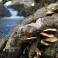
Near the spring, there were a few very old olive trees. We peeked into the open cavity inside one ancient tree and marveled at its twisty beauty.
On the Ascent
And then, there we were, climbing Mount Meron. The ascent up Har Meron is different than climbing most mountains. Rather than being sharp, the climb is very gradual, twisting back and forth through the trees on a path up to the mountaintop.
Of course, it was still a challenge. We made sure to stop for a few breaks amongst the trees as we slowly proceeded to the top.

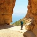
Along the way, there were some breaks in the thick tree cover. Here, we started to get a taste of the gorgeous views that awaited just a bit further up the mountain.
Summits
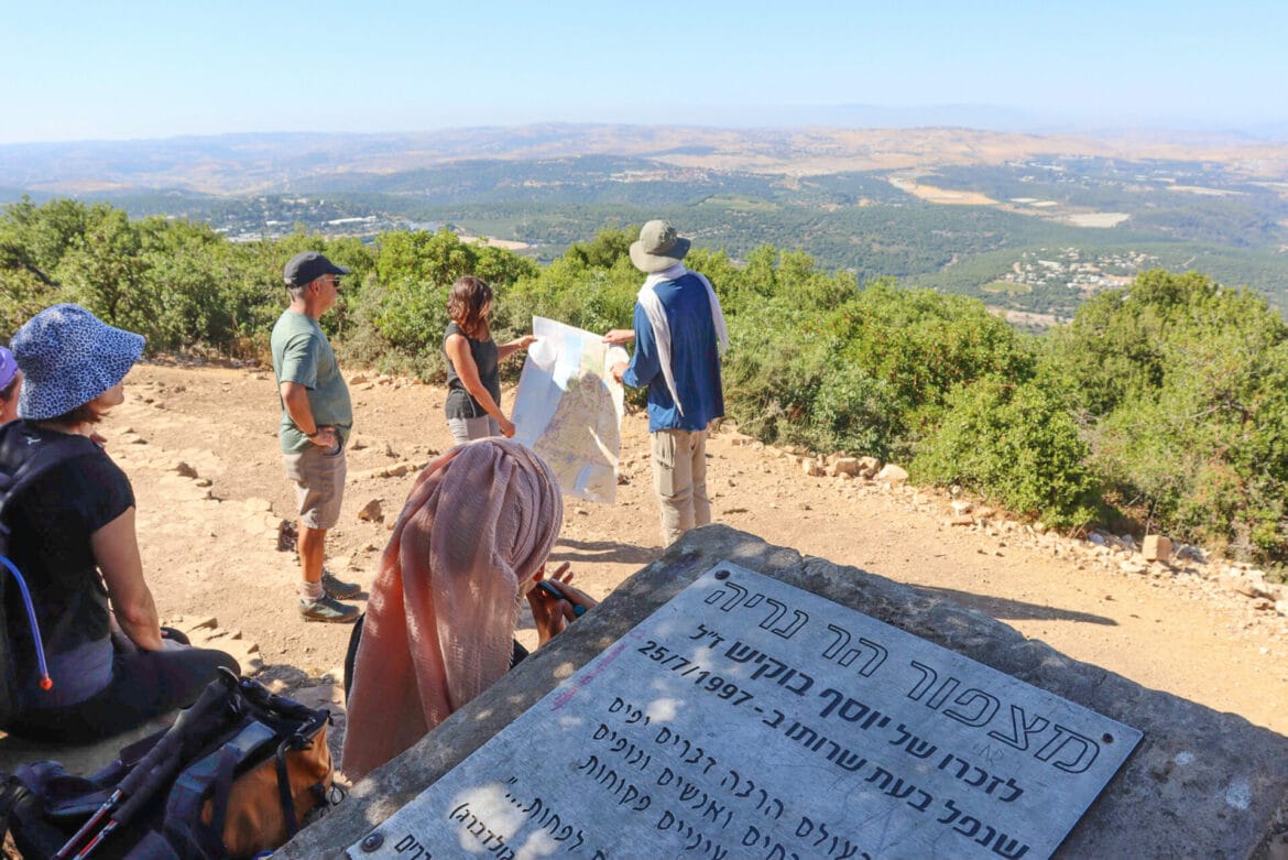
After a long journey through the trees, we reached the first summit in the Meron mountain range, at the Mount Neria lookout. Here, we took in incredible views of the Galilee at 1000+ meters. We could see Mt. Hermon in the distance. The border with Lebanon was clearly visible – its brown color contrasted with the green of Israel’s Galilee region.

We stopped here for pictures and an explanation, then continued on our way. It was 5:00 PM. And we were almost at the summit of Mount Meron.
We passed by an ancient olive/wine press where we stopped for another quick break. And then, we proceeded through the trees to the lookout.

It was spectacular. Although it was late in the day, we all had to stop and take a moment to gape at the beautiful view from the top of the mountain.
Wrapping it Up
After that, we made our way along the path through the trees to the parking lot, at the Shvil HaPisga picnic area. This spot was a perfect place to end the day. In the shadows of twisty oak trees, stone picnic benches sat side by side, waiting for our post trail festivities.
I lined up bottles of wine, cheese, and melon for the summertime, and we made a toast to our completion of the fifth segment of the trail. Then we sat relaxing and chatting for a long time. It had been an incredible journey.
Our hike to the top of Mount Meron had been a perfect way to spend a warm, summer day. This fifth section of the Israel Trail took us through dark, shady beauty to one of the most spectacular lookouts in Israel.

Hikers’ Notes:
Here’s what you need to know to hike this segment of the Israel Trail, from Nahal Tzivon to Mount Meron:
- This is a one way trail.
- This trail is suitable for all seasons.
- There is a campsite (with water) at the beginning of this trail (The Yitzchak and Leah Rabin Campground).
- Come equipped with plenty of water, a hat, and good walking shoes to hike this trail.
- There is another water refill point at the foot of Mount Meron, at Hirbet Humema. This is also a campsite.
- This hike begins on the blue trail, with a descent towards the Baram Forest through Nahal Tzivon. When you reach the crossroads, turn right to follow the Israel Trail to Mount Meron. The trail ends at Shvil HaPisga parking.
- If you'd like to hike this trail, but don't have a way to get back to the trailhead, you arrange a taxi from nearby Tzfat or Meron. Alternatively, you can continue on the Israel Trail for another 7 kilometers to the city of Meron and take public transportation from there.
- Use the trail map and the Google Earth file in the table at the top of the page to find your way on the trail.
Don’t forget to read my guide to the navigational features in this post before you hit the trail!
Trail map from Amud Anan.
Questions? Have you hiked this trail? Let’s hear about it in the comments!