| Trail Map | ||
| Distance: 8.2km | Time: 4 hours | Difficulty: Advanced |
| Ascent: 72.5m |
Click here to go straight to hike notes.
Last week, we experienced a bout of cool spring weather here in Israel. To me, that meant one thing: an opportunity to head south for one of our last desert hikes of the season.
My requirements for the trail were awesome climbing and desert pools. So we scoped out a trail that had a little bit of both, at Nahal Tahmason and Nahal Peres.
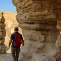
The first part of the trail at Nahal Tahmason was said to be a little bit sketchy. Trail markers were scattered and there was much discussion as to whether the descents were too dangerous. So we weren’t quite sure what to expect from that part of the trail.
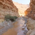
The second half of the trail led through Nahal Peres, a stream bed with standing pools near the Dead Sea. We had been to Nahal Peres before. But we had never hiked it in in this way, on a point to point trail from the beginning of the stream to the end.

As it turned out, this trail was a real adventure, full of all sorts of desert attractions. We enjoyed challenging climbing, beautiful views, and the last remnants of refreshing desert pools. It was a great day.
This trail was definitely not for novices. There were fear inducing descents along 30 meter waterfalls, all without hand hold rungs or ropes. It was perfect for us, but after hiking it I was able to understand why some thought it was unsafe.
Here’s how we hiked this challenging one-way adventure at Nahal Tahmason and Nahal Peres near the Dead Sea.
Where Are We?
We began our day with a pricey taxi ride, from the end point of the hike at Tzomet Arava to the starting point 10 minutes up the road. Getting out of the car, it was hard to locate any real beginning of the trail. There was a parking lot for cars, but after that there were no markers of any sort to indicate the way.

We followed the map down into the valley, towards the unmarked stream bed below. After a little bit of walking amongst piles of rocks, we began to see faint trail markers, some of them painted over with white paint. We continued along.
Off the Beaten Track
Pretty soon, the trail started to become more clearly defined. Trail markers began to appear at regular intervals. But still, they were painted over with a light red paint, as if to indicate some sort of danger (although the trail markers coming in the opposite direction were regular black trail markers.)
Strange trail markers aside, the hike through Nahal Tahmason was lots of fun. As we hiked, we reached one drop after the next, first a short drop down a “waterfall”, then a ten meter drop. We scouted out the path and figured out the best way to climb down each one.

Usually, it involved a roundabout method: going up and over rocks on the side, or climbing back and forth along ridges. But sometimes we got to slide straight down.
As we hiked, I couldn’t help but feel happy. Here we were in the desert again, the bright blue sky shining against the tawny rocks, a cool breeze blowing in our faces. It was silent. Everywhere. I was in the zone.
Verdict on the Climb
Finally, we reached the last, thirty meter descent. It looked pretty scary as we eyed it from up above. But as we made our way slowly down the side of the cliff, we realized that for experienced hikers, it wasn’t very difficult. (And in fact, we’ve been on many other trails that were equally fear-inducing and just as dangerous.)

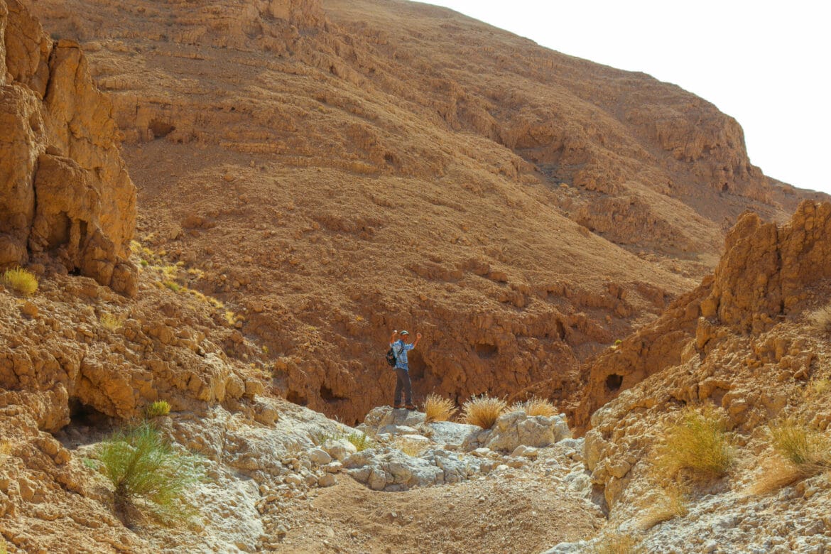
We climbed through the last of Nahal Tahmason, towards a flat ridge where another stream intersected. After passing by a lone acacia tree, we made our way towards another surprise: a small “fin” trail led us up a desert mountain, along a narrow path at the top.
At this high point in the desert, the wind blew fiercely. It was beautiful and incredible – we walked along on the top of the fin in the the bluster, feeling almost as if we would blow away.

Luckily for us, we made it to the end of the ridge and into our old stomping grounds at Nahal Peres.
Breakfast with the Birds
We knew exactly where we were headed next. At the beginning of Nahal Peres, there is a breakaway trail towards the best desert pools. On a shady ridge right near the pools, we had shared our muffin crumbs with the local birds a year or so earlier. Today, with our hot coffee and raspberry lemon muffins, we headed back towards the same spot.

After that challenging part of the hike, it felt good to relax there in a desert canyon. Our old friends the birds joined us for breakfast again, brazenly approaching to pick up fallen crumbs. Even with our hot coffee, it felt cool in the shade, our skin on the cool white rock of the smooth cliff. It was a wonderful place to stop.
When the last drops of our coffee were finished, we headed over to the standing pools. At first glance, it looked like they were all dried up. But a little further along, we found clear, knee-high water in several pools. I slid down to splash around a bit before continuing to the next part of the hike.

And I was so happy I did!
One Final Challenge
We had a decision to make. Would we continue along the (much easier) green trail to the end of Nahal Peres? Or would we choose the (much more difficult but much more fun) black trail for our journey to the end?
You can guess what we chose. That’s right. The black trail!
Last time we were here at the Nahal Peres, we had climbed up the black trail in the opposite direction. I remembered that at the time, I really wished we were climbing down the stream bed, so I could slide down along the smooth rocks that made up the pathway. I was happy to have an opportunity to fulfill my wish.

We sped through Nahal Peres, getting into full flow, hopping from one rock to the next. Whenever we reached a rock slide, we slid gleefully like schoolchildren on a playground. At a fast pace, this trail was ridiculous amounts of fun.
The time sped by, and before we knew it, we were facing a massive ascent back up the side of the canyon to exit the stream bed. We tackled this climb at a fast pace too, working up a sweat as we used metal rungs and hand holds to make our way to the top.
And One More Surprise
Once outside of the canyon, we could see white puffy clouds and the Dead Sea shining in the distance. We were almost there. We finished our walk up along the streambed, then proceeded down towards the end of the trail.

But there was one last attraction that we had to explore: on the side of the trail, old bunkers made of rocks and metal sheeting dominated the landscape. And they were open! We climbed inside the dark tunnels of the bunkers like moles in a maze, emerging into the light and dug out trenches.
After spending way too much time exploring, we hurried towards our car awaiting in the parking lot below. It had been an incredible Friday morning.
From crazy climbing to mountain ridges, desert pools to rocks slides, this hike at Nahal Tahmason and Nahal Peres had far exceeded our expectations. It’s rare to find so many types of fun and beauty on one mid-length desert trail. This trail is for hikers who love a really great adventure.


Hikers’ Notes:
Here’s what you need to know before hiking at Nahal Tahmason and Nahal Peres:
- This trail is for experienced hikers and climbers only. There are dangerous drops along the way. This trail is not for children, novices, or groups. The markings are not always clear, so do not attempt to navigate this trail without a map, compass, or other navigation system.
- This trail is best for fall, winter, and spring. The pools at Nahal Peres are only full in the winter and springtime.
- Not suitable for dogs.
- Don't forget to follow the breakaway trail (marked white, clear, white) towards the gavim at Nahal Peres before continuing onto the rest of the black and green trails.
- To hike this trail, we parked at the end, then took a cab (from Dimona) back to the beginning. This was quite pricey! Better to go with two cars or find a closer place to take a taxi from. The end point of the trail is Tzomet Arava, so you can price out a ride (10 minutes up the road) before you go.
- The beginning of the trail is not marked (May 2022). For this reason, use the Google Earth file in the table at the top of the page to find your way on the trail.
- In addition, you can use the trail marker gallery and trail map in the table at the top of the page to get a sense of your direction before you go.
- Trail colors: black, Red Trail/Israel Trail, green, black.
Don’t forget to read my guide to the navigational features in this post before you hit the trail!
Trail map from Amud Anan.
Questions? Have you hiked at Nahal Tahmason? Let’s hear about it in the comments!