

| Trail Map | Ascent: 235m | |
| Distance: 5km | Time: 2-4 hours | Difficulty: Moderate |
Click here to go straight to hike notes.
Where do you find a gushing river, shady pathways, and history all woven together into a 5 kilometer hike? At Nahal Amud Reserve in the Galilee, all of this comes together in a setting of great natural beauty.
There are lots of ways to hike Nahal Amud. You can take a long, one-way trail that follows the river to the tall pillars that it’s named after (amud = pillar in Hebrew). We opted, instead, for a 5K loop trail through the National Park that covers a lot of the beauty of Amud in a manageable hike.
The trail was green, shady, and quiet (in January). In the summertime, it’s still green and shady, but it turns into a popular spot for an escape from the summer heat.
As opposed to some water hikes, Nahal Amud is full of history. Located near Safed, the river used to provide water for the holy city (during the time of the British Mandate). So, there’s an old pumping station, a police station, and a flour mill on the trail.

In typical National Park style, the trails are well marked with lots of signs explaining artifacts and structures on the site.
Here’s how we hiked this beautiful trail in the Galilee:
Anemones and Old Buildings
We pulled into the parking lot early in the morning – we were the only ones there. At the booth, we showed the worker our Parks Card in exchange for a map and an explanation of the trail. Then we set off down towards Nahal Amud.
As we started, we saw a splash of crimson peeking out from the side of the trail: the first anemones of the season. Soon, these flowers will form a red carpet over the ground at many nature sites around the country. We were excited to see the first blossoms of the season making an appearance.

We walked past the old British Police Station. It was built here to guard the pumping station and protect the water supply to Safed.
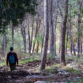
Next we followed the trail downward, still in the sunshine, descending towards the dark valley below.
It’s Getting Kind of Hairy
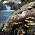
As we descended, the scenery began to change. A thick layer of bright green moss lined every wall. Flowers cascaded down the sides of the rocks in the sunshine, then disappeared when we crossed over into the shade. In the darkness, hanging moss and vines poured down from the trees.

The pathway was a carpet of oak leaves. We could now hear the gush of Nahal Amud through the trees. Along the side of the path, there was a channel of water, a remnant of the water supply system of the past. We followed it past the pumping station, towards a stone seating area and an out of use fountain, covered in vines and moss.
Old Orchards, a Flour Mill, and the River
There are antiquities and ruins all over Israel. But at Nahal Amud, we could actually feel and envision the history around us.
The trail led along a beautiful pathway through the trees from one old building to another. These little structures felt very British – white walls and iron gates covered in ivy and moss.

Next we reached old orchards of olive trees, an unusual find at the bottom of a riverbed. We passed by the flour mill, a crumbling stone structure where the power of the river was once harnessed to grind wheat. Finally, after reading many signs and exploring many cool structures, we reached Nahal Amud itself, gushing through a tangle of trees.
Water Power
Just as we reached the river, the trail began to loop back in the other direction. We followed it along the shady stream.
At Nahal Amud, there were boulders and rocks strewn around the river, creating whitewater pools. At first, it didn’t look quite suitable for swimming – the river was powerful and harsh in mid-January.
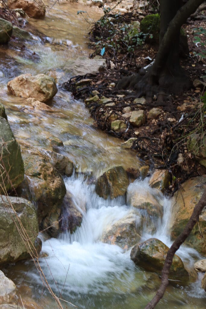
But as we progressed along the pathway, we came across crystal pools, fed by mini-waterfalls. One after another, these pools of water appeared off the pathway, each one its own miniature swimming spot too cool off on a hot day.
In the wintertime, taking a dip wasn’t an option. But we did enjoy climbing out onto the mossy rocks to take pictures. Waterfalls poured out of moss-covered caves into turquoise pools of water. The scene was magical.

What Goes Down Must Come Up (or Something Like That)
Now that we had gotten to the absolute bottom of the descent towards Nahal Amud, we found ourselves heading steadily uphill, over stone steps and rocks. We were so immersed in the river bubbling alongside the path that we barely noticed the ascent.
Soon, we reached the end of the line for Nahal Amud (at least for us). In this spot, two rivers (Nahal Amud and Nahal Meron) joined together to form one larger one. We said goodbye to the sights and sounds of the river and started the real ascent.

From here, we traveled up, out of the moss and ivy, towards the flowers and sunshine. Lots of flowers and many steps later, we were back at the trail head.
There are lots of water hikes in Northern Israel. But Nahal Amud is uniquely interesting and beautiful. At 5 kilometers, it’s a multi-season trail that almost anyone can tackle.
As for us, we’ll be back. I can’t wait to spend a long summer day with the kids, re-discovering the history and magic at Nahal Amud.


Hikers’ Notes:
Here’s what you need to know before hiking this trail:
- Nahal Amud is a National Park. There is an entrance fee (or you can use your National Parks card. ) Facilities and maps are available at the site.
- This trail is great for families. There is a climb at the end, so expect your kids to get tired.
- No dogs allowed.
- Swim at your own risk! (This means you can swim there, but there are no life guards.)
- Use the free map you’ll receive when you enter the park to follow the loop path.
- Trail colors: red, black, blue, black, red. The path is clearly marked.
Don’t forget to read my guide to using the navigational features in this post before you hit the trail.
Trail map from Amud Anan.
Here’s a link to the brochure from the Parks Service.
Questions? Have you hiked Nahal Amud? I’d love to hear about it in the comments below!


Dis Nahal Amud today with my kids. It was an absolute blast!. The hike down was pretty and not to difficult, we found ourselves a pool and then we hiked back up the Nahal through the pools.
A definite recommend
How long do you think this would take with little kids (youngest is 3)?
Hi. Is there a campsite and if so is it a free campsite at Nahal Amud?
Edgar Milwid
Is this doable in august heat with kids ages 4-7.5? Ive read that the trek back up is steep and no shade. But not sure who to believe. So many alarmists 🫣
Great family hike. Did this hike today with family of two adults and four children. As described way down is fun and way up a bit of a challenge for the littler ones. All in all two hours really depends on the time you spend at the bottom
Hi. Any thoughts on Nahal Amud these days (7-26)? Safety etc always a question… I think OK. Is there a maslul that does Upper (water) + Middle (pegs on mountain) then circles back to start (no Lower)?