

| Trail Map | Terrain View | |
| Distance: 7.4km | Time: 4- 6 hours | Difficulty: Strenuous-Advanced |
| Ascent: 643m |
Click here to go straight to hike notes.
Masada. It’s one of the most popular tourist attractions in Israel.
After the destruction of the Second Temple, this desert fortress was the site of a famous standoff between the Roman Army and the Jews who lived there . To escape from Roman oppression, a group of Jews made their home at Masada, building ritual baths and synagogues and settling in. After a lengthy Roman siege, Masada finally fell, but not after its inhabitants had taken their lives.
It makes sense that Masada is such a popular tourist attraction. This site is both interesting and accessible. Cable cars and paved pathways make the 400 meter ascent up the mountain and its rocky terrain easy to traverse. So almost anyone can visit this incredible historical site.
More active types enjoy tackling the winding Snake Path which leads right to the top of Masada. But there’s another way to approach this famous desert fortress.
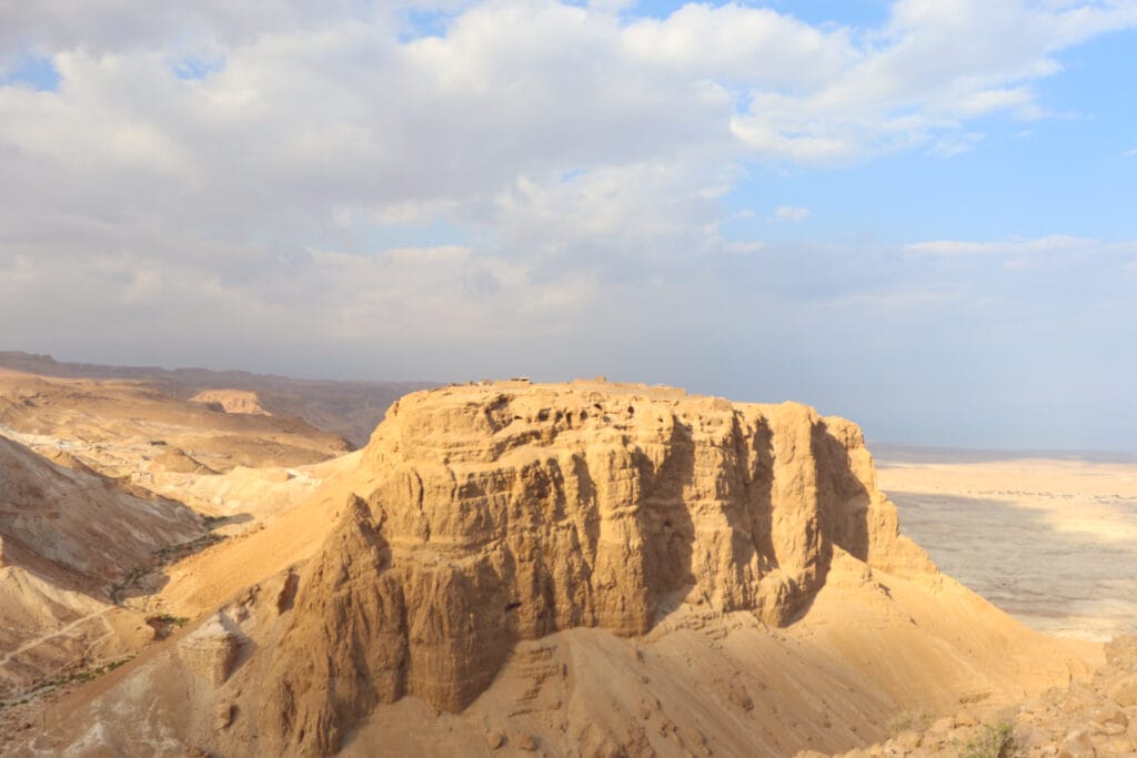
This past week, we took an 8 kilometer trail that circled around the mountain of Masada, with a short detour up to the top right in the middle of the hike. Hiking it this way gave us an entirely different perspective on the desert mountain. We climbed over challenging terrain and took in gorgeous views of mountains, rolling hills, and the Dead Sea. As we climbed, we got a real sense of just how impenetrable this fortress actually was.
This was one of my favorite recent hikes. I just loved the rugged terrain, incredible views, and the fact that we got to see a familiar place from an entirely new angle.
Here’s how we hiked this challenging 8k trail around Masada:
The Beaten Path
The hike began unlike any other. We pulled into an indoor parking lot and made our way through the underbelly of the Masada Visitors Center.
Starting this way actually wasn’t so bad. It gave us a chance to pick up a map and run our Parks Card (tip: pay the entrance fee for Masada here if you don’t have a card).

We emerged from the building into gentle sunshine. Grey clouds covered most of the sky. It was a great day for a desert hike. We found the red trail (Runner’s Trail) and were on our way.
A Heavenly Perspective
Our main goal at this point in the morning was to find a place to stop for coffee. It had been a long drive, so it was late in the day. We were ready to get away from the hubbub of visitors and cable cars and find a silent spot to immerse ourselves in nature.
We traversed the path quickly, climbing up and down past a Roman encampment or two until we found the perfect spot: a flat rock overlooking rolling desert hills, the Dead Sea a reflective glint in the distance. Right there, we pulled out our thermos of coffee and got comfortable on the rocks.

As we sat, we took in the grey storm clouds and refreshing breeze and felt very lucky. Most tourists don’t get to experience Masada like this. For many visitors, Masada is an interesting, but hot and sunny, desert attraction with paved pathways and lots of people.
On this stormy December day in the desert right past Masada, the experience was beautiful, dramatic, and silent.
Ready to Climb
After our break, we continued to hug the mountain on the red trail. Soon, we reached the green trail, which we would now follow as we ascended towards the top.
Since we were climbing about 400 meters, the trail was challenging at times. In some spots, the path barely hugged the cliff edge, a metal handhold providing extra security against a dangerous fall. But there was a lot to notice along the way.

We saw the remains of fall squill flowers, the bright green leaves popping up from desert soil. There were beautiful birds swooping through, stopping close in the hopes of receiving bread crumbs. And the views: gnarly caves, red rock, and the stark mountain that is Masada contrasted to the white rolling hills and the placid sea in the distance.
The Final (?!) Ascent
At long last, we reached the breakaway trail to the top of Masada. This is where the Romans were finally able to penetrate, after years of laying siege on the Jews who lived there. We climbed the Roman ramp, ascended a few sets of steps, and we arrived: at an arched entryway to the remains of the fortress up above.

We breathed a sigh of relief as we reached the top. Climbing is fun – but we had reached the end of the challenge part (or so we thought!).
The Fortress
Now, we were free to explore the ruins of the great fortress. We wandered around the top, peeking in at ritual baths, residences, and cisterns. It was impressive all over again to see the complicated structures and resources that supported Jewish life at Masada for many years.
Woven into the system were the remnants of other eras: a Byzantine church stood on one side, its walls covered in mosaics. Herod’s beautiful palace protruded on a nearby cliff edge.

Masada is a desert mountain. Water is hard to come by in this neck of the woods. A complicated series of cisterns and aqueducts (created by Herod) had supplied captured rainwater to the top of the mountain, for drinking and bathing.
After reacquainting ourselves with the area and its story, we headed back down through the archway and towards the rest of the trail.
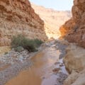
A Riverbed
Back at the red trail, we proceeded down into a desert riverbed. After the first of the winter rains, this trail was green and lush compared to its surroundings. Little flowers blossomed on short shrubbery.

Now that we had revisited top of Masada, we enjoyed the view up from down below even more. We could just make out the remains of crumbling walls along the craggy mountain edge. The bright blue, puffy cloud filled sky perfectly contrasted against the fortress’s red rock.
Oops
As we walked, we neared a cliff edge. According to our map, we would soon be turning slightly left to make our way around the mountain. But all we could see was a steep ascent along a giant hill right before us. This couldn’t be our trail. Or could it?
After checking the map once more we realized: this was not to be a simple walk back to the trailhead. In order to encircle the fortress, we first had to climb all the way up this mountain, getting a birds eye view of Masada before circling back to the beginning of the trail.
So, we decided to stop for another break.

The views from our lunch spot were incredible.
Challenging, Awesome
After break #2, we were on our way again, climbing up a rocky trail towards the tippety top of another desert mountain. I’m sure it was challenging, but I don’t remember having any real trouble. After a long, hard, climb, we found ourselves situated above Masada, peeking in as a Roman scout may have long ago.

From up there, we could see the tourists, the structures, the Dead Sea in the distance. Still, Masada did look impenetrable – the sheer cliff edge would have seemed an impossible point of attack.
The Real Challenge
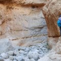
The most important rule of hiking? What goes up must come down! We were actually shocked when we saw the black trail that would lead us back down and towards the end of this hike. At the beginning of this black trail, the Parks Authority had posted a sign: Warning, Dangerous Descent. And dangerous, it was.
We climbed down along the edge of a cliff, carefully navigating. Any serious misstep could lead us right off the side of the mountain. Sometimes, it seemed like the trail itself was going to lead us off the edge of the cliff. But each time it seemed that there was nowhere to go, we saw an area of safe passage just around the next bend.

All throughout this part of the hike, the views were unbelievable. When you’re on the actual edge of a cliff, they almost always are. On one side, Masada protruded into the clouds. On the other, white rolling hills made up the terrain.
After a long and terrifying descent, we reached the bottom and headed back towards the trailhead.
Worth Every Step
After completing this trail, I felt lucky that I had been able to experience this piece of Jewish history from such an unusual perspective. Hiking around Masada in this way, I was able to get a real sense of the fortress’s place in the landscape. Now, we better understood why the location of Masada appealed to the Jewish rebels, despite the challenges of food and water that came along with desert terrain.
Not only that, but the trail had been challenging and beautiful…which is pretty much everything you would want out of a desert hike.
This ring around Masada was a lesson in Jewish history and perseverance and an exciting adventure through an area of great natural beauty.


Hikers Notes:
Here’s what you need to know to hike this trail around Masada:
- Best suited to cooler days in fall, winter and spring. Much of this trail is exposed and would be too hot to hike in the summer, or on very warm days.
- On sunny days, bring a hat and sunscreen. Make sure to carry along plenty of water.
- This is a challenging hike. Only attempt it if you are physically fit.
- Not suitable for dogs.
- This trail is not suitable for those with an intense fear of heights.
- Parts of the trail are suspended over cliffs and sheer mountain edges. Wear solid, closed toe hiking boots. Exercise caution when walking near ledges.
- To follow this trail, use the trail marker gallery and the trail map in the table up top along with the Google Earth file.
- Entrance to Masada requires payment of an entrance fee. Make sure to pay this fee (and register in advance online, if necessary) before ascending. Pick up a pamphlet at the entrance to help you get acquainted with the ruins at Masada.
Don’t forget to read my guide to the navigational features in this post before you hit the trail!
Trail map from Amud Anan.


You finally got that challenging hike you’ve been itching for! It looks amazing, but it looks like one I’m going to enjoy through your writing and camera lens because I don’t see myself actually surviving the descent . . . or maybe even the ascent for that matter! Thanks for the write-up!
It was definitely a challenge 🙂
Did this last week. It really was challenging. Hardest hike we’ve done in a while. It’s worth noting that as it’s a loop, you can start from either side of Masada, which is useful if your’e staying on the western side.
Thanks for your comments!
Your links at the top to the map, google and trail marks are not working.
Just taking back to this page.
I’m sorry. must have been a glitch. it’s working now. You can erase my comment