| Trail Map | Terrain View | |
| Distance: 17.7km | Time: 5- 6 hours | Difficulty: Strenuous |
| Ascent: 594m |
Life has been happily full for the past month or so here at the Hiking the Holyland home base. My son got married, and along with the preparations for that celebration came the requisite influx of visitors—friends and relatives—and the weeklong festivities that followed the affair. Needless to say, I am quite a bit behind on hike posts.
So today, I’ll be digging back in my memory to a camping trip we took about a month ago to the Ramon Crater.
The trip was both planned and spontaneous—we knew we were going away for a night but didn’t know where until the evening before—and our adventures unfolded in much the same fashion. We set out with one trail in mind and ended up completing an entirely different loop. And so we found ourselves hiking an 18-kilometer loop from the Be’erot Campground to Mount Ardon and back. We didn’t get a particularly early start, so we watched the sun set over the crater from the top of Mount Ardon, then walked down and back under the light of the full moon.
It was a great day.

I’ve learned in life that some of the most memorable adventures occur when you follow your heart and throw caution to the wind. That sunset-to-moonlight hike to Mount Ardon in the Ramon Crater was definitely one of them.
That night, we barbecued under the stars and pitched a tent at a quiet, beautiful campsite that we discovered late in the evening.
When I think about how little planning went into this trip, it’s remarkable what an incredible time we had.
Here’s how we hiked that day’s trail, from the popular Be’erot Campground to Mount Ardon and back.
From Be’erot Campground
After searching in vain for parking near the trail we had originally planned to hike that day, we headed instead to Be’erot Campground, a popular campsite in the crater. From there, several trail options led to various hotspots. We figured we’d piece a few trails together to create some sort of circular loop. It was already noon by the time we reached Be’erot, so we anticipated a mid-length hike—about 10 kilometers or so.
We set off on the trail towards Ein Saharonim. The weather was beautiful that day—a perfect day in the desert, with blue skies and a cool breeze. We were so happy to be far away from civilization, hiking through the quiet wilderness.

Soon, we reached Ein Saharonim, a spring that produces an abundance of mud puddles and a beautiful cluster of tall reeds, right in the middle of the crater. We explored the scenery there, then walked up to the Saharonim Fortress, a Nabatean fortress that sits on the ancient spice route.
The first-century CE fortress is beautiful, remarkably well preserved, and seems a little out of place right in the middle of the giant crater. We took in the views and got back onto the trail.
Picnic Break
Next, we hiked towards Ramat Saharonim (Saharonim Plains) and Herut Hill. We had hiked part of this trail before, on a short family trek a few years back. The scenery was beautiful—colorful and quiet. After a short while, we scoped out a perfect hill from which to take in the views and eat lunch.

We climbed up, emptied our bags, and prepared our sourdough baguette sandwiches. It was quite windy on that hill, which meant that we really had to hold onto our food, lest it all go flying off into the canyon. It made for a very entertaining (and delicious) lunchtime.

Sometime during our lunch break, we looked at the map once again. It seemed to me that we would finish this hike well before nightfall—and I wasn’t at all ready to be nearing the end of our Ramon Crater trek. So I suggested that from Herut Hill we continue walking towards Mount Ardon. We could re-evaluate our timing once we reached that turnoff, then decide whether to climb Mount Ardon or turn back.
With our new plan in place, we packed up our bags and set back out on the trail.

Making Good Time
Now that we had a more ambitious hiking plan, we were going to have to move. We took off through Saharonim Plateau towards beautiful Herut Hill in all its multicolored, variegated beauty. Then we broke right and followed a trail down through the valley towards Mount Ardon.
When you’re committed to a goal, it’s amazing how fast you can move. Mount Ardon loomed large before us, and step by step it grew larger and more towering.
It didn’t take us long to reach the foot of the massive ascent.

Let’s Climb
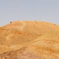
We hadn’t planned to climb a mountain that day. But boy, were we excited to do it. The last time we had climbed Mount Ardon was in the first months of Hiking the Holyland, when we approached the peak as Israel hiking novices. We remembered it being quite difficult back then, and we were curious to see how our years of experience would change things.
Indeed, this time around, it seemed far less daunting. We climbed up the peak, our speed boosted by our exhilaration. The sky was absolutely beautiful in the late afternoon sun. Clouds had begun to form, and the sun had started its descent.

We had to stop several times to take in the magnificent views of the crater.
Then, almost without warning, we reached the end of the steep ascent. The trail began to snake upward slowly, higher and higher, towards the absolute top of Mount Ardon.
We made it!

Sunset
From the top, we watched as the sun set across the sky. Suddenly, it grew cold and breezy. We added a layer and continued to hike, knowing that we had a long way to go before nightfall.

As we descended the slightly less steep side of Mount Ardon, the sun set completely and the nearly full moon rose higher. By the time we reached the bottom of the descent, it was completely dark. The last several kilometers of our journey would take place under the dim light of the moon.
Walking at Night
I’m not sure which part I liked more: spontaneously climbing Mount Ardon at sunset or hiking back to the campground by moonlight. This stretch of the walk was flat and followed a wide jeep trail, which made for easy, fast hiking. Still, it took at least an hour to make our way back towards Be’erot.

We entertained ourselves by singing songs as we hiked along. It was incredible how much light the moon provided in the darkness of the crater. Soon, the night sky revealed an extraordinary array of stars. Since Ramon Crater is a Dark Sky Reserve, the stargazing is truly spectacular.
We made our way through the darkness, taking in the divine beauty of the Ramon Crater at night.
Onward to the Campsite
After a long while, we reached our car at Be’erot Campground. The campsite was bustling, with roaring bonfires and happy campers. We preferred the quiet of a less popular campsite, so we studied the map and found Gevanim Nightcamp.
After an incredible day of adventure, we pitched our tent, fired up the grill, and popped open a couple of beers. Our day had given us everything I could possibly want out of a nature hike: adventure, beauty, exhilaration, and unexpected surprises.
This 18-kilometer loop trail to Mount Ardon is a perfect adventurous trek through the Ramon Crater, an amazing natural wonder in Israel.


Hikers’ Notes:
Here’s what you need to know to hike this circular trail to Mount Ardon from Be’erot Campground:
- This is a circular trail.
- This trail is best for cooler days in the fall, winter, and spring.
- Not suitable for dogs.
- Wear good hiking shoes and bring plenty of water and sun protection to hike this trail.
- There are bathrooms at the trailhead (Be'erot Campground).
- Use the trail marker gallery, trail map, and maps in the table at the top of the page to find your way on the trail. There are several trail colors to follow. Use the trail map to get a complete picture of the hike before you begin.
- This is a circular trail.
- This trail is best for cooler days in the fall, winter, and spring.
- Not suitable for dogs.
- Wear good hiking shoes and bring plenty of water and sun protection to hike this trail.
- There are bathrooms at the trailhead (Be’erot Campground).
- Use the trail marker gallery, trail map, and maps in the table at the top of the page to find your way on the trail. There are several trail colors to follow. Use the trail map to get a complete picture of the hike before you begin.