| Trail Map | ||
| Distance: 11km | Time: 6 hours | Difficulty: Advanced |
| Ascent: 673m |
Click here to go straight to hike notes.
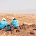
On this year’s Alyn Heels of Love Hike, we got to hike for days through the desert near Eilat and take in some of the most awe-inspiring scenery in Israel.
Even the most basic trails in the Eilat Mountains are simply spectacular. Between the Eilat Mountains, red rock stream beds and (dry) waterfalls combine to form climbing trails that can get any adventurer’s heart pumping. There are mountains to ascend, unbelievable views to take in, and spectacular rock formations to behold.
The scenery is, perhaps, even more enjoyable because it is so quiet there. Some of the trails around Eilat are well-traveled (Mount Shlomo, for example), but on others, it is rare to see other hikers.

On the first day of this year’s multi-day hike with Heels of Love, we hiked a long trail through Nahal Tzfunot to the Hidden Valley. From there, we climbed up towards the Amram Lookout where we hopped onto the Israel Trail. The Israel Trail took us past tall pillars of stone (Southern Amram’s Pillars and the Shehoret Pillars) until we reached our destination at Shehoret Campground.
The hike was amazing: not surprisingly, it had absolutely everything one could want out of a desert trail.
Here’s how we hiked this 10 kilometer, one way adventure from Nahal Tzfunot to the Shehoret Campground in the mountains of Eilat:
Just Another Valley
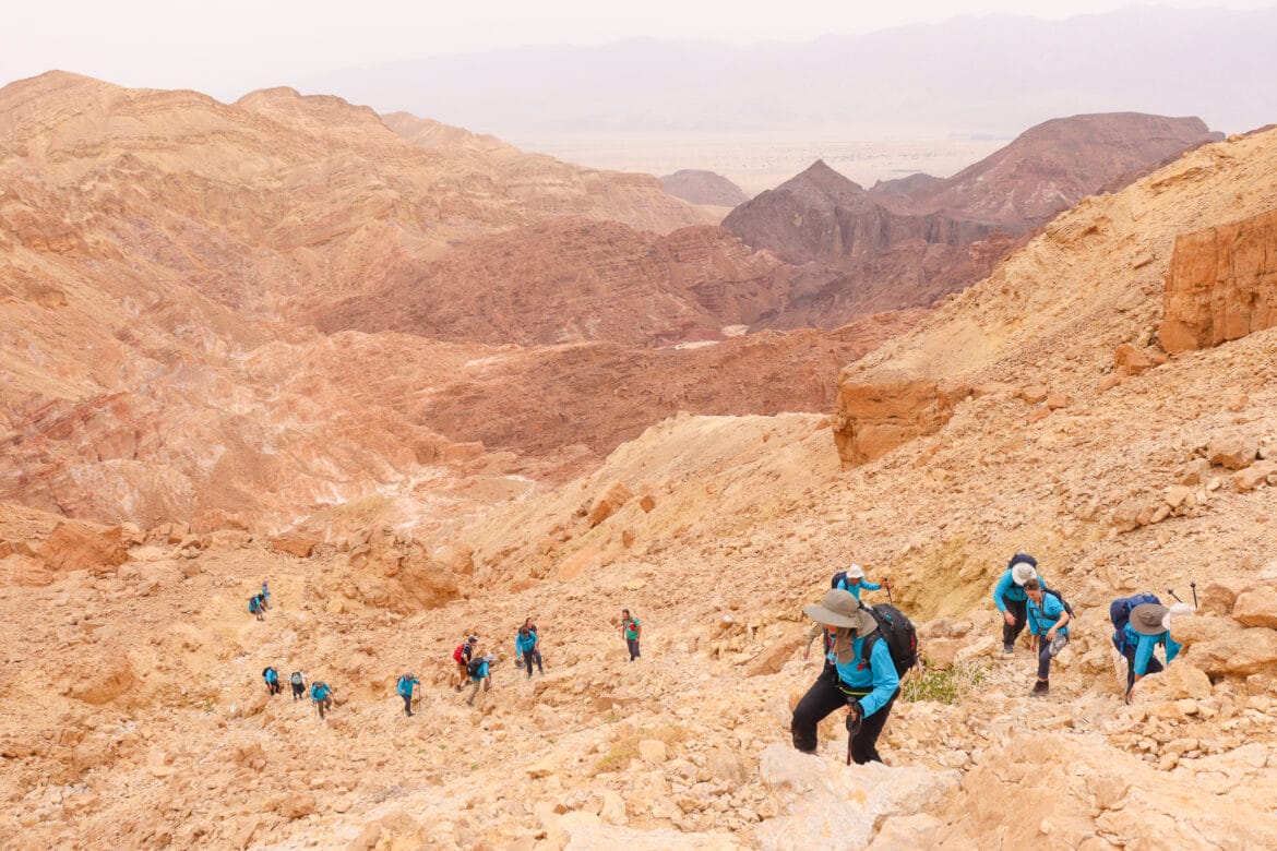
After a short walk on a wide, flat, jeep trail, we began to hike through Nahal Tzafra, a quiet little valley between towering peaks of red rock. This trail was a beautiful challenge, as any good desert stream bed trail should be. In the shade, we climbed over big boulders and past dried up, golden plants.

Pretty soon, we found ourselves hiking uphill, ascending a mountain that seemed to be made of crumbling red rock. It took some focus and footwork to reach the top of the hill. But once we were there, we were treated to flatter ground and beautiful views. All around, the ruddy stone mountains were piled up like ripples of an ice cream sundae. One cone shaped hill even looked like it had a cherry on top.
After a short stop, we continued to walk downhill towards the Tzfunot Waterfall.
Chasing Waterfalls
There are no free rides in the mountains of Eilat. The downhill part of this trail was just as challenging as the uphill. No sooner had we reached the bottom than we were treated to another steep climb – this time up the Tzfunot waterfall.
In the desert, a waterfall isn’t actually a waterfall in the sense that we think of it. Rather, it is a place where rainwater falls whenever the rains are plentiful. They flow here through dry stream beds into the Red Sea.

After a short walk on the red trail, past a large caper bush, we reached the waterfall and began to climb. We utilized full body motion as we put all of our limbs to work to navigate the steep, rocky ascent. It was lots of fun.
Nahal Tzfunot
Next, we headed through beautiful Nahal Tzfunot. This stream bed was a bit more open and less cavernous than the previous one we had hiked through. A white path snaked between layers of picturesque mountains, giving this part of the trail the very appropriate name, “The Hidden Valley.”

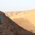
We walked through the Hidden Valley for a while, enjoying the spectacular scenery before climbing up and out of its depths. Then, we reached a spectacular view out to the multicolored mountains all around, dubbed the Hidden Valley Lookout. Here, we took some photos and then continued on our way, along a trail which seemed to have no shortage of incredible views.
As we walked, we soaked up the stunning beauty of our surroundings. Black mountains, red mountains, and white valleys turned what could have been a boring desert landscape into something spectacular. It’s no wonder that some people consider the Eilat Mountains to be one of the most beautiful parts of the country.

Soon, we reached another jaw-dropping view at Amram’s Lookout.
Onto the Israel Trail
From here, we continued onto the Israel Trail, past rock piles arranged in new, geometric shapes. At this late point in the day, we had picked up the pace quite a bit. Late afternoon had arrived, and we were going to have to hurry if we wanted to finish the hike before sunset.

Luckily for us, the Israel Trail part of this hike was relatively easy walking. We followed a straight path which took us through all types of scenery. There were more mountain views, rolling desert hills, and red rock backgrounds. After walking this way for a while we reached Southern Amram’s Pillars (not to be confused with Amram’s Pillars, further north). The tall columns of pinkish rock towered over us, another example of the ancient beauty of the area’s terrain. These strange looking rocks had been formed long ago, by geological phenomena that we could only imagine.
Last Leg
We continued past the pillars on the clearly defined trail, absorbing the scope of towering rock formations as we hiked. It was cool to see how the color of the rock transitioned from a pinkish to a dark brick hue. Next, we reached the Shehoret Pillars, our last landmark before arriving at the campground.

From the pillars, it was a simple hike in near darkness towards the campground where we would spend the night. We arrived there exhausted and happy, ready for a hot meal and a good drink. Luckily for us, on the Alyn hike, that’s exactly what we got at the end of the day.
At the campsite that night, I thought about our day as I gazed at the stars. As usual, our hike in the mountains of Eilat had been an amazing experience. We had seen so many beautiful sights that day that I could hardly remember them all.
What I was left with was a feeling of peace and joy, remnants of a day spent climbing through a rock world in one of the most beautiful places in Israel.


Hikers’ Notes:
Here’s what you need to know to hike this trail from Nahal Tzafra to Tzfunot to Shehoret Campground in the Eilat Mountains:
- This is a one-way trail.
- This trail is best suited to cool, winter days. This area is not recommended for warm days in fall, spring, or summertime.
- As with any desert trail, check the weather forecast for flash flood warnings before you go.
- There is a no-frills campground at the end of this trail where you can spend the night. (Check for current details about water point locations. At the time of this writing, there was a water tank at the campsite.)
- Wear good hiking shoes, a hat, and sun protection to hike this trail. Bring 4 liters of water for the day.
- This is a challenging trail requiring upper body strength as well as endurance.
- To follow the trail: Park your car or grab a taxi to the black trail. Take the black trail to red. Make a right to follow red. When you reach the Israel Trail, make a left. You will follow the Israel Trail all the way back to the Shehoret Canyon day camp. From here, follow the dirt road down to the campsite. (You can also order a taxi to this spot.)
- Use the TRAIL MAP in the table at the top of the page to find your way. The Google Earth file will help you stay on track.
- For added safety, equip yourself with a paper map or use Amud Anan when you hike these one way trails in the desert.
Don’t forget to read my guide to the navigational features in this post before you hit the trail!
Trail map from Amud Anan.
Questions? Have you hike this trail? Let’s hear about it in the comments.