| Trail Map | Terrain View | |
| Distance: 8km | Time: 3-4 hours | Difficulty: Strenuous |
| Ascent: 220m |
Click here to go straight to hike notes.
It’s that time of year again! During fall in Israel, before the winter rains, great hiking trails are hard to come by. Much of the terrain in Israel is looking dry and parched. Water levels in natural springs are low. It’s still kind of warm outside. What’s a nature lover to do?
My solution to this problem is desert trails at sunrise.
In the desert, the lack of rain doesn’t really make that much difference in the beauty of the terrain. Yes, it can be hot out there, but as long as you begin walking with first light, hiking in the desert can be quite pleasant.
So last Friday, we found ourselves back in the desert just after sunrise. Our plan was to begin at Kfar HaNokdim and hike through Upper Nahal Rahaf. Then, we would cross over a little mountain and loop back through the open desert to complete the trail.
We didn’t quite know what to expect. We hadn’t read about the trail or seen pictures. But usually, when we head out into the desert, we find something amazing. So, Thursday night, we packed up our bags, got ready for an early start the next morning, and went to bed with our fingers crossed.

And boy, did we luck out. Upper Nahal Rahaf was particularly beautiful, especially early in the morning. The canyon we walked through was defined and interesting. There were cool caves, birds and animals, and plenty of fun climbing. Our desert wild card was a success.
Here’s how we hiked through Upper Nahal Rahaf one autumn morning:
From a Bedouin Village
We pulled into the Southern Parking lot at Kfar HaNokdim and found the trailhead. It wasn’t particularly well marked, especially since it was a section of the Israel Trail. But we found it and set out into the open desert, continually on the lookout for the next faded trail marker.
We passed by a small Bedouin encampment and a flock of sheep. And soon, we found ourselves in what was clearly a desert stream bed: Nahal Rahaf.
At first, the trail didn’t lead through Upper Nahal Rahaf. Rather, we walked alongside it. In the early morning light, we could see our shadows reflected on the walls of the canyon as we walked.
In the Nahal
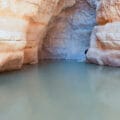
After a little while, the trail brought us right into Nahal Rahaf. As we walked, the walls of the canyon became more defined, progressing from gentle hills to taller cliffs. There were cool caves and rock formations on the side of the trail.
Once we were deep in the canyon, we decided that it was time to stop for breakfast. We had no idea what was coming up ahead. And at that moment, we were in a beautiful, shady valley with pretty views out to both ends. It was the perfect place to stop and relax.

We pulled out our coffee and pear muffins and got comfortable on some big flat stones. It was heavenly. Despite the promise of unseasonable heat that day, I was practically chilly in the early morning shade.
And it was quiet there. So quiet. I could feel the silence ringing in my ears.
Time to Climb
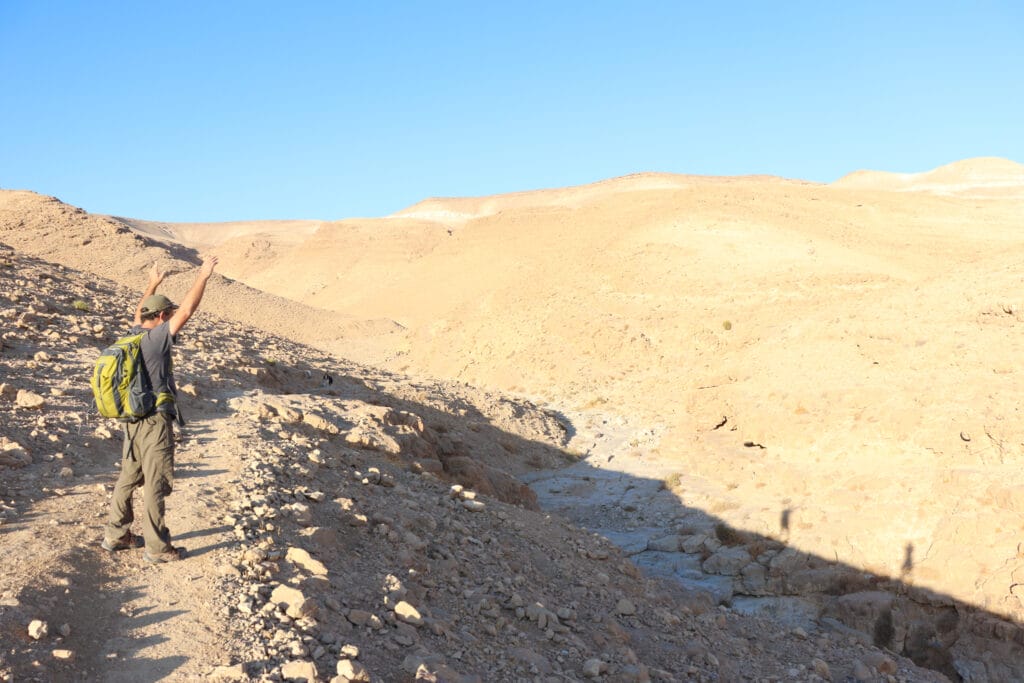
After a thoroughly relaxing break, we packed up our stuff. It was time to get moving. We were hoping for more shade and more canyon walls. But perhaps we would be walking out in the open sun. It would be better to hike early than get stuck walking in the midday heat.
Within a few minutes of our breakfast stop, we discovered that we were in for a treat. There was climbing in Nahal Rahaf! It wasn’t the organized type, with hand hold ladders and serious ascents. But it did require a bit of full body movement to climb up meter high ascents from one level of the canyon to the next.

We always enjoy this type of desert terrain. It seems just perfect how the rock in the desert provides so many neat handholds and foot holds, simply built in to the canyon.
After a few steady ascents, we found ourselves facing an open area surrounded by towering hills of rock.
Into a Cave
From our spot in Upper Nahal Rahaf, we could see what looked like a multileveled cave up above. And although the cave wasn’t exactly on the trail, we decided to go explore. So up we climbed.

On the way, we saw evidence of human inhabitation in this isolated part of the desert – a wall had been built up against a smaller cave, as if to turn it into a home. Further up, we reached the multileveled cave. A flock of doves made their nest in the upper level, safely out of reach of human hands.
Out into the Sunshine
After climbing down from the cave, we continued along. Soon, the canyon walls began to recede. We were out in the open sun. Then, we reached the green trail, which took us across the desert next to the foot of the mountain and towards the return pathway.
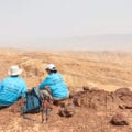
On this part of the trail, we seemed to be descending through another stream bed, this one shorter and steeper. Before completing the descent, we took a pit stop at a flat topped cliff. From there, we could see out to all sides of the desert, the Dead Sea on one side and rolling mountains on the other. It was an incredible sight to see.

Next, we got back on the trail and descended to the bottom of the canyon. From here on out, we would essentially be walking through the open desert.
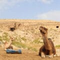
But first, we had to find our way along the trail through another Bedouin encampment.
Where Things Get Tricky
The thing about Bedouins is that they kind of plop their tents down anywhere: even right in the middle of a trail. Between the camels, the sheep, and the frisky barking dogs, we had quite a time staying patient and finding our way from one green trail marker to the next.

It took some focus and mental energy, but soon, we had managed to cross through the Bedouin encampment on the green trail. We made a left onto the blue trail which would take us back across the desert towards the trailhead in Kfar HaNokdim.
The Home Stretch
This part of the trail was simple and straightforward. All we had to do was head out along a flat path towards Kfar HaNokdim, a little oasis of green in the distance. From here on in, we were able to hike without much focus, just steadily heading back through the desert sunshine towards our final destination. After a long walk, we could see our car gleaming in the sun.
This trail through Upper Nahal Rahaf had been so much more than we had expected. A cool canyon, beautiful birds, fun climbing, and desert silence had been ours that morning. This trail had been a great way to experience the beauty of the desert on a Mediterranean autumn day.


Hikers’ Notes:
Here’s what you need to know to hike this trail at Upper Nahal Rahaf:
- This trail is suitable for cooler days in the fall, winter, and spring. As with all desert trails, check for flash flood warnings before you go.
- This is a circular trail.
- This trail can be suitable for very athletic dogs only. Aside from the climbing, there also might be some issues with Bedouin dog encounters at the last part of the trail. (When we were there, the pack of dogs barked and approached our dog, but we managed to steer clear of any altercation.)
- Wear sun protection, good hiking shoes, and bring plenty of water to hike this trail. There can be shade in Nahal Rahaf, but at midday, the trail will be mostly exposed to the sun.
- Re parking: We parked on the side of a rocky road right at the trailhead. You can also park in the Southern Lot of Kfar HaNokdim. Exit the lot to find the trailhead (Use the Google Earth file for assistance).
- The trailhead is very poorly marked. See the trail marker gallery for assistance.
- Re: following the trail. Once you are on the Israel Trail, follow the Israel Trail and black trail markers through the canyon. Trailmarkers are located at regular intervals, so make sure to stay in sight of them. At the end of the canyon, you will reach the crossroads to green. Turn left to follow the green trail over the hill and through the Bedouin encampment (if it's still there). There are trail markers at regular intervals, but they may be hard to find due to tents and animals blocking them from view. Once you reach the blue trail make a U-turn to head back along the blue trail. The blue trail is poorly marked, but you will be able to see Kfar HaNokdim in the distance. Just head in that direction.
Don’t forget to read my guide to the navigational features in this post before you hit the trail!
Trail map from Amud Anan.
Questions? Have you hiked this trail at Upper Nahal Rahaf? Let’s hear about it in the comments!